Smallest EMWIN antenna

Status
Please reply by conversation.
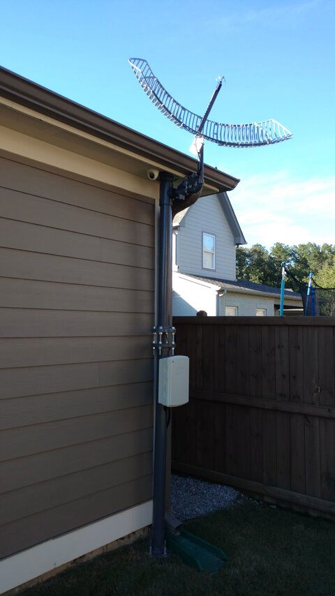
I'm actually rather surprised at how sturdy it seems to be. We had some 20mph wind yesterday and it didn't budge a bit. I figured the dish would at least wobble a bit on the horizontal plane but nope, nothing.

Since it's just temporary, nothing is actually attached to the house, nor is there any concrete in the ground, I drove four two-foot lengths of threaded rod into the ground and then bolted a plate onto them. The main post is two sections of 3-inch schedule 80 pipe which has an outside diameter of 3.5-inches. Instead of bolting it to the house. I left a gap between the two sections and used two plates with some threaded rod and bolts to basically compression fit the post between the ground and the eave of the house. It's hard to tell but there's a piece of high-density foam between the top plate and the eave.
 

Attachments

  • IMG_20160814_173630636.jpg
    IMG_20160814_173630636.jpg
    837.2 KB · Views: 207
Trip,
I would go ahead and continue with your setup. The EMWIN N signal will be around for a bit longer. If you have the gear continue to set it up and get to see what's there.
My most likely guess that GOES R will replace GOES East, The GOES East sounder went down some time back and that is an important tool for the weather forecasters.
I know that when I use the WXmessage internet feed the servers that are there are not from the gov, they are from private servers, one I know of is in Cuba with a downlink station there.
I have been told that EMWIN (currently) is at capacity for what it can handle, and from what I have seen it is. When there are multiple severe weather events over the nation or a very large area the EMWIN system is at full capacity to handle all the data in it.
I also have been told that the new EMWIN will have the equivalent GVAR satellite images in it and that would be a good reason to need much more bandwith. But from what the info says the dish will remain the same as now to receive it.
All in all I am not a bit surprised that with the new satellite that they are upgrading EMWIN as well. Also keep in mind that we here in the states are not the only users of this system as there are many islands and other nations withen the viewing range on GOES that use this data as well. Also understand that NOAA in terms of earth stations a 1000 bucks is cheap.
Though I now to us it isn't. There is someone making a new setup that will be on the market in about a year but you won't like the price and I'm not going to give it. It can be done cheaper.
JW2016,
To what I know that there are no weather data reception methods (free) using micro buds.There may be a subscription service that may offer this but not a free one (again that I am aware of). NOAAPORT has to have a 10' dish, mabie 8' down along the equator.
I currently use NOAAPORT as well and the system can be built very cheap due to the use of DVB-S2 format and software available. I have an article a few pages back how to build that IMPD grid antenna.
doubleoh,
Glad to see that it's working for you, though check the sub reflector as it looks it's bent way too much angle. Also make that sub reflector solid so the antenna has a better Front back ratio. My suggestions.
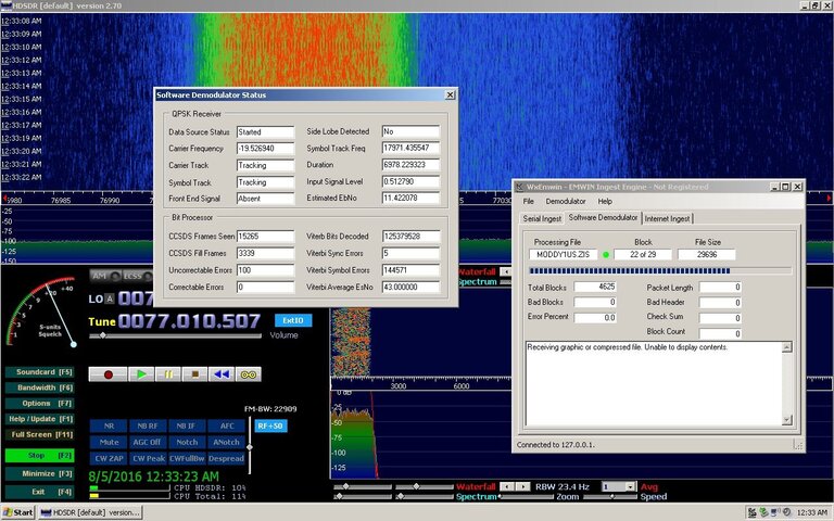
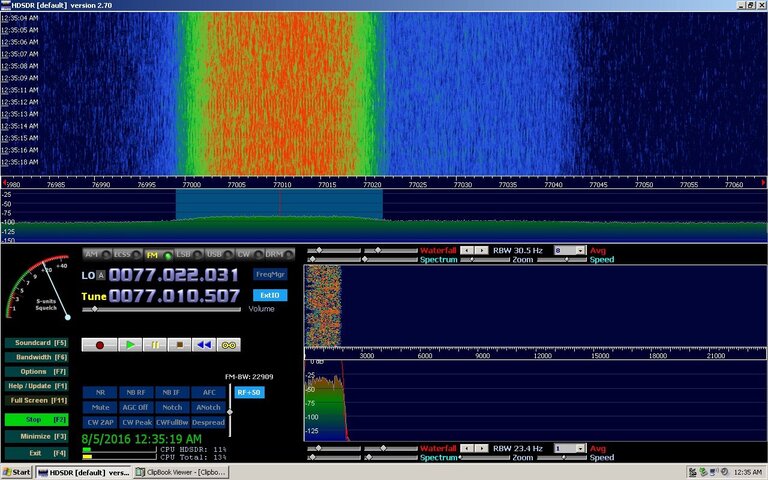
And lastly here are my pics of the past good setup, Using my 12' GVAR dish for the signal input.
HDSDR 1.jpg HDSDR 2.jpg
 
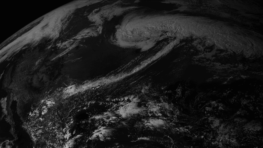
If what I was told is true you can expect quite a change in resolution. What I found on the LRIT page is just the EMWIN combined with current LRIT (what they are calling HRIT).
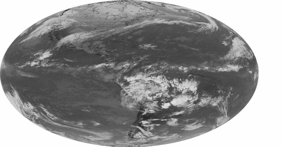
Current LRIT images:
2004_0106_2045.G12_FDIR.JPG northAmerica.png
Theses were images I found on the internet, The Vis image may not be a good example of the vis channel for the current LRIT. I would recommend that you talk to Joe at USA satcom for some sample data from LRIT. I don't have that data.
LRIT is a subset of data from the GVAR dataset. To see GVAR pretty close to it full resolution see this page:

http://weather.msfc.nasa.gov/GOES/

You can choose from different sectors and satellites, zoom, animate and color the images with the java tool on the page. It's also very near real time data. refresh every 10 min to see current data.
If they are to use the high resolution GVAR images ( similar to NOAAPORT ) it would be a great change. LRIT replaced the WEFAX transmissions. Talk about low resolution, wow.
a slight tech. description of the three.
GVAR 10 resolution @ 2.11 Mbps
LRIT 8 Bit resolution @ 128 Kbps
EMWIN current @ 19.2Kbps

Timothy KC0HWG
 
I would recommend that you talk to Joe at USA satcom for some sample data from LRIT
He's been traveling this week but when he gets time he's going to send me a copy of the LRIT decoder to try. So hopefully I'll be able to obtain some LRIT images myself fairly soon!

LRIT replaced the WEFAX transmissions. Talk about low resolution, wow
I remember those days! It was better than nothing but sometimes they were barely useful.

Should say,
GVAR 10 Bit resolution @ 2.11 Mbps

Little more tech info:
GOES R
GRB >10 bit resolution @ 31 Mbps
EMWIN/LRIT (HRIT) @ 400 Kbps
I don't even want to know what size dish GRB is going to require.
 
I don't even want to know what size dish GRB is going to require.
GRB is said to be able to use a 12' dish, though I have heard of the need of 15'.

LRIT is much better than the the old WEFAX transmissions, That's when EMWIN was at 9600 baud. Though the receiver was much more simple for the reception of WEFAX then LRIT. But with the SDR hardware coming along that has changed alot.
 
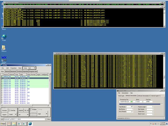
Btw, I have successfully moved from receiving EMWIN to receiving LRIT! Screenshot attached.

Thanks to everyone here in this thread for the help with the dish/signal issues and thanks to Joe for the decoder!

The only "problem" I'm having at the moment is with xrit2pic not automatically generating images from the lrit files. I *think* this is because xrit2pic has different channels coded in for the GOES satellites than what is sent in the LRIT files. For example, xrit2pic has VIS007, IR_107, IR_039 and WV_066 as the GOES E/W channels whereas the lrit files I'm receiving have channels IR04, WV03 and VS01. I've sent an email to the developer but I'm not quite sure what to do other than that.
 

Attachments

  • Screenshot (54).png
    Screenshot (54).png
    63.8 KB · Views: 182
GOES R launch delayed, More part issues. EMWIN webinar below.
Doubleoh my sub reflector is bent a 33 degrees. bolth sides.
---------------------------------

The US National Weather Service (NWS) will host its second Emergency Managers Weather Information Network (EMWIN) Stakeholders Teleconference at 1400 EDT (1800 UTC) on August 30, 2016. The information presented will include changes in the GOES-R satellite launch and EMWIN service transition schedules, as well as additional details on the future EMWIN and GOES-R High Rate Information Transmission (HRIT) services. Participants will have the opportunity to have their questions answered during the teleconference. To participate in the teleconference, please register by going to;


EMWIN Stakeholder Webinar - August 30, 2016

Join us for a webinar on Aug 30, 2016 at 2:00 PM EDT.

Register now!

https://attendee.gotowebinar.com/register/1637010462758972674

After registering, you will receive a confirmation email containing information about joining the webinar.

View System Requirements

If you do not receive a confirmation email after registering please contact me.

Thanks.

John Simensky
Meteorologist National Weather Service
Dissemination & Outreach
Silver Spring Maryland
(301) 427-9318
 
Thanks!


Shocker. I'm going to go ahead and call it. We won't see GOES-R take up a east or west position until VERY late 2017 or early 2018.

So it might may make sense to purchase a commercial system for the current EMWIN. Problem is one is no longer selling systems to new customers and the other one doesn't respond to e-mail inquires so they may not be selling either. Guess it's time to build one with an SDR , grid antenna with an LNA amp. The new system from GOES-R (whenever they can get it up) looks great but I think NOAA should produce an EMWIN type stream receivable with small antennas and reasonably priced equipment for text products only with watches/warnings given priority of course. The HRIT stream would be available for persons who want graphics plus EMWIN. NOAA WeatherWire isn't bad, but there have been 2 instances when both my internet connections (I have DSL and Cable for redundancy) have gone down at the same time during severe weather. The home power remained on, but both connections died. Satellite reception would be much more reliable than relying solely on the Internet for wx data. Have been looking at XM weather for radar and other graphics plus watches/warnings but it's expensive and I don't know how well it updates. Nice thing about that service, the receiving antenna's are nice and small and the service does not suffer from rain fade. So who the hell knows what the future holds. The conference call should be interesting.
 
So it might may make sense to purchase a commercial system for the current EMWIN
Nah, I wouldn't waste the money. My DIY EMWIN setup with the grid dish breaks down like this cost-wise:

1) 2x TP-Link Grid Dishes: $89.54 ($44.77 each) - http://goo.gl/YP5beK
2) LNA: $150 - http://www.downeastmicrowave.com/product-p/1691lnah.htm
3) AirSpy R2: $169 (on sale atm)
4) Decoder (from USA-Satcom): $50
5) 7ft LMR-400 with N and SMA connectors (You may need a longer cable): $20.17 - http://goo.gl/OlQWGg
6) N-Male to N-Male coupler (connects LNA to grid dish): $4.98 - http://goo.gl/EAqiUX
7) Misc hardware for IMPD Grid Antenna build: I had these parts but I'd say $5 (if that)
8) Power supply for LNA: $8.18 - http://goo.gl/WAQEHT

Total: $496.87 - Misc shipping charges not included. Mounting pole also not included. A little concrete and a metal pole are cheap though.

For an additional ~$475 I bought an Intel NUC to have a dedicated computer for EMWIN but that's not necessary. Either way that still comes in way under either of the commercial systems available for the same functionality with the added bonus of being able to re-use parts when GOES-R is functional.

Have been looking at XM weather for radar and other graphics plus watches/warnings but it's expensive and I don't know how well it updates.
It's actually not a bad service. A bit over-priced though. If you're in range of a FIS-B ground transmitter then you can grab some low-res radar from 978/UAT signals. Code: https://github.com/mutability/dump978
 
I will be uploading the EMWIN webinar here soon for anybody that wasn't able to attend, many questions got answered from that last one. Many addressing the byteblaster service and the internet. It's about an hour and 20 min long.

Sildes of the webinar

EMWIN Stakeholder Presentaion 160830 final r160830-1000 - 2.pdf
 

Attachments

  • EMWIN Stakeholder Presentaion 160830 final r160830-1000 - 2.pdf
    1.3 MB · Views: 1,001
Last edited:
I will be uploading the EMWIN webinar here soon for anybody that wasn't able to attend, many questions got answered from that last one. Many addressing the byteblaster service and the internet. It's about an hour and 20 min long.

Sildes of the webinar

EMWIN Stakeholder Presentaion 160830 final r160830-1000 - 2.pdf

Well it's good news that a 1.0 or 1.2 meter dish can be used, but NOAA still hasn't decided where GOES-R is going to go. Another issue is the stupid FCC making available frequencies to cell phone providers that may interfere with the new GOES-R frequencies. Hopefully a commercial system would be offered, but we might be on our own which is doable. Thanks for posting the PDF of the presentation.
 
Last edited:
Here is the audio of the webinar, Use the slides in the pdf from above. The webinar has had non informal information removed as well as dead time to run faster and smoother. As with the last webinar the names of the hosts and me are the only names (one software vendor name) that are not edited out. File size is around 675 MB.

http://www.filedropper.com/emwinwebnair2

I have also provided some info on the spectrum that is right next to the HRIT that is now called AWS-3 (Advanced wireless services) that is the auctioned off portion.

AWS3bandplan.pdf

By doing a little research I found that Verizon has won this portion of the spectrum.
Unless the phones and gear that they make in this spectrum are RF clean we here in the US will not be able to use HRIT. (this is my opinion)
Because the cell TX mitters will desense the HRIT receivers. (again my opinion)
I recommend anybody in the US considering an HRIT setup do research before making/ buying any hardware/software for HRIT direct reception. Make shure that there will be no cell spillover on the HRIT downlink before investing in a earth station. This can be done with the current SDR testing that has been tried here.
Unlike what was said in the webinar this will affect large portions of the US in all areas. (unless you happen to be in a fed RF protection area)
Otherwise we wait...
 

Attachments

  • AWS3bandplan.pdf
    135.4 KB · Views: 1,514
Honestly, at the rate they're going, it's going to be very late 2017 or 2018 before GOES-R takes up position as east or west. So I'm not even worrying about this for now.

Ultimately though, I think it's going to be hit or miss whether the Verizon signal creates interference. If you're not too close to a tower and can position a large object (house, barn, etc) between the tower and the dish, you might be okay. I have a cell tower that lights up my backyard with noise like a freakin purpose-built noise generator. However, I've been able to overcome that with shielding.
 
I guess I will move forward then. The past three months have been "hell". Bought a 2nd home for sick inlaws...was remodleing...had fire...closing Atty. didnt pay home insurance...so no insurance...then found 50% of home was termite damaged....county condemed.....we get to pay morgage for next 20 years on 1.5 ac of land.....AND...we get to pay to demolish house....

So...as you can see,,,not much time for radio/sat stuff....

But..I will find time!!

Trip - KT4WO
 
On Wednesday, Joe at usa-satcom did a presentation about receiving L-Band weather satellites at the 20th Cyberspectrum Software Defined Radio Meetup recently. Its on YouTube and his talk starts around 10 1/2 minutes from the beginning:


He demos his hardware setup, and then discusses his demodulation software for the various signals he has encountered. I'm very impressed with what he has done!
 
Status
Please reply by conversation.

Wallyhts??

Users Who Are Viewing This Thread (Total: 0, Members: 0, Guests: 0)

Who Read This Thread (Total Members: 2)

Latest posts