Newbie needs guidance!

Definitely incorrectly assembled. It is currently assembled to use scale "A".

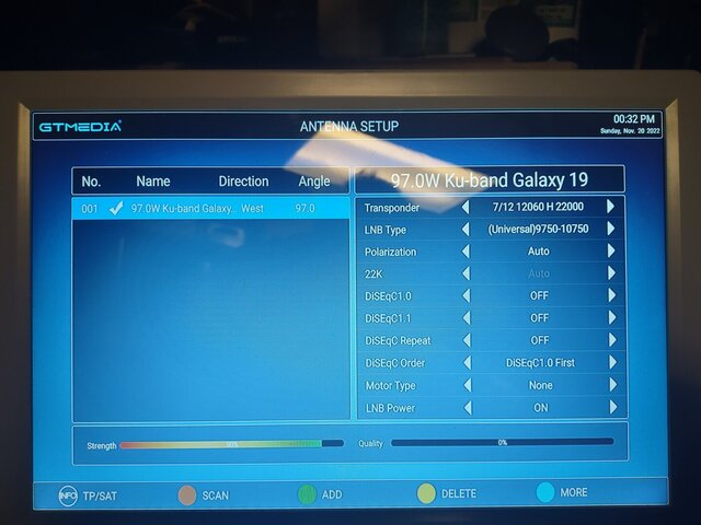
The STB photo shows transponder 11836. This transponder is no longer active. You will not find the satellite with an inactive transponder. Other posts have mentioned active transponders. I often use 12060.
 
  • Like
Reactions: primestar31
Definitely incorrectly assembled. It is currently assembled to use scale "A".

The STB photo shows transponder 11836. This transponder is no longer active. You will not find the satellite with an inactive transponder. Other posts have mentioned active transponders. I often use 12060.
12060 it is.... as for the assembly. It has been done exactly as the diagram shows other than using their base only. the is no "A" markings anywhere other than the base mount and angled pole which is not used in my set up. Pole is too short for my rig.
 
In your last photo, there is a hole at the top of the bracket that has a "B" stamped beside it. It appears that the bracket is assembled using the hole beside it. If you disassemble the bracket, you will see that the bolts are currently installed in the hole stamped "A".
 
The satellite and its bracket is assembled correctly as in diagram. Please disregard base. "b" bracket is installed correctly. Thanks though.
 
In your last photo, there is a hole at the top of the bracket that has a "B" stamped beside it. It appears that the bracket is assembled using the hole beside it. If you disassemble the bracket, you will see that the bolts are currently installed in the hole stamped "A".

The satellite and its bracket is assembled correctly as in diagram. Please disregard base. "b" bracket is installed correctly. Thanks though.
Michael, please listen to Brian (Titanium), he REALLY knows what he's doing on these, even more so then the majority of us posting here. I'll post another picture, and where I outlined in RED, is what he means. The bolts to the LEFT of that hole are presently in "A", they NEED to be in "B" on both sides, IF you are going to use the "B" elevation settings on that side. Since you say your elevation is supposed to be above 50, "B" is the proper hole to put that in.
IMG_20221119_122448144_HDR.jpg
 
I agree, Brian (Titanium) knows what he is talking about. You said it is a 39” dish but your instructions are for a 33” (85 cm) dish.

Also, 12060 H with a symbol rate of 22000 just to be sure you have the polarity and SR correct.
 
ok, I can see what you mean with the photo. I'll reassemble first thing in the am. Thanks the pic does show the hole. i could not see it while on the roof. Many thanks and sorry for the confusion.
 
  • Like
Reactions: FTA4PA
ok, I can see what you mean with the photo. I'll reassemble first thing in the am. Thanks the pic does show the hole. i could not see it while on the roof. Many thanks and sorry for the confusion.
It IS confusing, and you aren't special in that, LOL!

FTA equipment in the USA is typically really VERY poorly documented. It's mostly so generic, and can be so sloppily built, there's all sorts of UNKNOWNS involved. KU signals are so small, YET, the "slop" alone in a dish can be so large, it's enough to make you want to tear your hair out, drive you to drink, AND maybe make you finally pick it all up, and THROW it off the roof!

Stay with it for now though, once you are finally done with this one, any additional installs will be much easier for you.
 
  • Like
Reactions: FTA4PA
Do you have a staight edge and a digital level - inclinometer (or a level app on your phone)? If so, we will move beyond this discussion about the bracket scale being correctly assembled. We will see if the elevation angle of the dish is set correctly. An offset dish appears to be aimed at lower elevation than the actual look angle to the satellite. This manufacture's dish has a 24.6 offset.

In an earler post you said that the elevation angle for the 97w satellite is 52.7 degrees at your install location.

If you were to place a straight edge on the dish edges along the vertical axis of the dish (12 o'clock/6 o'clock) and subtract the offset angle of 24.6 degrees, the dish would then be pointed at approximately the correct elevation to receive the 97w satellite. The digital level would display approx. 28.1 degrees.

Here is the math: 52.7 degrees - 24.6 degrees = 28 .1 degrees.

Hope this makes sense and brings success.
Thanks guys. I'll reassemble and try it out. They way it is right now seems like I have been off quite a distance and no wonder why i am not hitting anything. I will look in the near future for a much better quality. I wish i knew where to get a good one. Seems like I got trash this time around but didn't know any better. Guess I was a dumb ass but had to learn the hard way! Thanks again I am sure to have better luck tomorrow. LOL!
 
Looking at the elevation scale, that has the lines UNDER the numbers, I'd expect the elevation indicator mark UNDER the bracket.
The photo in post #99 seems to show a mark, at present position 55 degree elevation.

I would set the dish purely vertical, and then look at the value at the elevation scale. I'd expect it to be exactly the offset angle value.
Edit: If not, then there might be an assembly problem/error.

When the dish has a flat dish face, the offset angle can be calculated from width and height of the dish. But Brian already says it's 24.6, for this dish.

I would try to solve the elevation scale unclarity, before trying to find any satellite. (First things first!)

Greetz,
A33

Edit2: By the way. When you've disassembled the dish, you might take the opportunity to stringtest the dish; when it is a flat dishface dish. That is: put some thin ropes (or whatever you call it in english) across the dish, at various angles. When the dishface is still flat, the ropes should barely touch. When the dish is warped, the ropes touch heavily, or there is space between the ropes. Then you'd have to de-warp, first!
 
Ok if you still can't get, it is a way of cheating and this is how you do it, get your elevation close like you got it now go to receiver using USUSAL and put in your
latitude and longitude now once you have done that select a satellite like galaxy 19
97w and make sure on the screen your USUSAL is select for that satellite, your dish should turn, once you know the dish has turned go to your satellite dish and connect your meter to the LNB and select a strong TB, now move the elevation slowly up and down to see if you get any signal, now loosen the dish just a little so you can move it back and forth slowly you will get a signal with this trick, once you get a signal keep working with it util you can peak out your signal.

make sure on your meter and on your receiver you have the LNB as 10750 that is standard for a Ku LNB.
 
Ok fixed the dish... It did elevate the direction. Ran a scan at proper elevation. No go but I guess I'll start moving it side to side ever so gently.
 

Attachments

  • IMG_20221120_123225923.jpg
    IMG_20221120_123225923.jpg
    199.6 KB · Views: 70
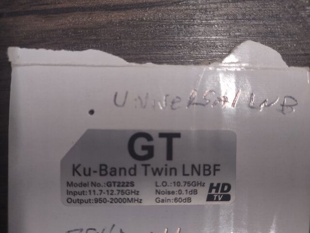
Also just wanted to post pic of lnb info.
Ok fixed the dish... It did elevate the direction. Ran a scan at proper elevation. No go but I guess I'll start moving it side to side ever so gently.

Make sure you change your lnb type to standard at 10750 as that unit is not a universal type. ;)
 
  • Like
Reactions: primestar31
Mark your starting point then swing SLOWLY left then right from it. If you don't get a lock raise or lower elevation a TINY bit then repeat above. If all is working you should eventually acquire a signal and lock doing this. Remember SLOW movement and TINY adjustments are the key. :)
 
Mark your starting point then swing SLOWLY left then right from it. If you don't get a lock raise or lower elevation a TINY bit then repeat above. If all is working you should eventually acquire a signal and lock doing this. Remember SLOW movement and TINY adjustments are the key. :)
Ok adjusted lnb now going to move a micro tad.
 

Attachments

  • IMG_20221120_123225923.jpg
    IMG_20221120_123225923.jpg
    199.6 KB · Views: 70

Nasa Tv

Titanium C138 and C1PLL spectrum graphs and 5G