Confused

  • Server Issues.

    We are very aware that there have been system issues the past few days. In troubleshooting the system, it has been determined that the issue is at our provider and is hardware related. As of 12:05 PM ET our provider has moved us to a new server.

    Things seem to be running better on this new server. However in trying to diagnose the issue (before finding out it was a hardware issue) we made some system changes which we need to undo. So if you find any issues or errors please let us know in the Operations Center Forum.

    Thank you for your patience! Sorry for the issue!
    CLICK THE X IN THE TOP RIGHT CORNER OF THE BOX TO DISMISS THIS MESSAGE
If you get actual channels you can check against lyngsat listings. But for some, you may have to ask. I checked against my listing in my satellite receiver (none of the transponders you listed are on lyngsat as one is a feed and the others are data transponders).

Good info. I don't believe I have 101w ku even scanned in. :):thumbup
 
  • Like
Reactions: Keith Brannen
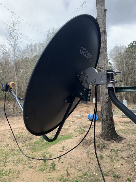
In your post you show a photo of the dish mount post clamp "A" scale set to 34 degrees elevation. This clamp does not appear to be assembled correctly.

The top bolt that passes through the clamp should be a single long bolt, which sits on top of your mounting post. in your photo, the mount is not sitting on top of the post.

Also, there are no bolts installed in the 3 clamp holes. Install and loosely tighten the 3 short bolts to loosely close the clamp onto the post. Tighten just enough to allow the dish to rotate with some friction. Once a satellite is located and the signal optimized, finish tightening the clamp bolts.
 
  • Like
Reactions: primestar31
Also, for Naples, Texas, the 97w satellite is at around 51 degrees elevation. For a fixed install (with no motor) the dish elevation mount bracket needs to be assembled to use the "B" scale. The clamp needs to be inverted and the top through-bolt needs to pass through the clamp's "B" hole. Now use the elevation scale "B" on the opposite side of the mount.

Maybe you could post a updated photos of the dish elevation bracket as it is currently assembled and mounted on the post.

Sounds like you are getting close to locking in on 97w.

Address: Naples texas
Latitude: 33.2032°
Longitude: -94.6802°

Satellite: 97W GALAXY 19 (G-19)
Elevation: 51.3°
Azimuth (true): 184.2°
Azimuth (magn.): 182.7°
 
Last edited:
  • Like
Reactions: primestar31
I marked as per instructed and can easily return and find 101 W. I put a pvc ring under the motor support and can easily rotate but as of yet I’ve not been able to lock on to any other satellites…
 
Yes sir the picture I took was before I put the 3 bolt clamps back in but they’re in now. The vertical post actually has 3 slots in it and my bolt is passing through the middle slot. I am actually not in Naples but 10 miles or so away. I’ve used location finder on dish pointer to get exact location.
I’ve been using the compass on my phone and moving 8 degrees east of 101 and just a bit higher on the elevation.
I sure appreciate all the pointers and advice! One step at a time…this too shall pass.
 
This is what it looks like at present.
 

Attachments

  • 655820DE-35CB-4E90-A550-0ACA28B70CEA.jpeg
    655820DE-35CB-4E90-A550-0ACA28B70CEA.jpeg
    230.2 KB · Views: 103
According to dish pointer there is a 6 degree difference in elevation and 7.2 degree (magnetic) difference in 101 W and 97 W. I have tried and tried to no avail…
 
Waiting for meter to reach full charge before going back for more attempts. What would .6 degree be equal to on the side of dish elevation scale? I moved the azimuth by Iphone compass but haven’t been successful yet…
 
Waiting for meter to reach full charge before going back for more attempts. What would .6 degree be equal to on the side of dish elevation scale? I moved the azimuth by Iphone compass but haven’t been successful yet…
Since the scale is 2 degress between lines then just under 1/3 of the distance between lines - so a very small amount. Never been a fan of apps for settting up my dishes. I use a regular old compass and a Johnson angle finder from Amazon. :rolleyes

Amazon product ASIN B00004T807
View: https://www.amazon.com/dp/B00004T807
 
  • Like
Reactions: phlatwound
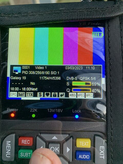
I shall order one! Thank you. I’ve spent literally hours today trying to find another satellite east of this one. Since transponders are not listed on lyngsat is it possible that this isn’t 101 W?
 

Attachments

  • 7E885F45-D22C-4AB2-BD43-3729E33E4F1A.jpeg
    7E885F45-D22C-4AB2-BD43-3729E33E4F1A.jpeg
    206.6 KB · Views: 79
I shall order one! Thank you. I’ve spent literally hours today trying to find another satellite east of this one. Since transponders are not listed on lyngsat is it possible that this isn’t 101 W?
I'm certain it is 101W, I get Video 1, and it also has the same PIDS as listed on your meter. I also checked other satellites in the vicinity, and none match.

My suggestion is to start at 101W, change the elevation to what you need for 99W, and manually move the dish very slowly, and in very small increments eastward (just nudge it so the LNB moves no more than say half a inch or less) and pause to see if anything scans in. Repeat until you get 99W to come in (check Lyngsat, or post here with the transponders/channels you get). Then mark its position, change the elevation to 97W, and repeat the above. I can't stress enough the small movements, and the pauses.
 
  • Like
Reactions: FTA4PA
I have a motorcoach that has a Whineguard (lol) Direct dome that seeks and locks on to their birds. I’ve not used it in years, and I also have the little Dish tailgater that does the same thing. Has anyone ever used this technology and perhaps replaced the lnb and input through a program or computer database to seek all of the satellites that are visible in whatever location it is set?
 
I have a motorcoach that has a Whineguard (lol) Direct dome that seeks and locks on to their birds. I’ve not used it in years, and I also have the little Dish tailgater that does the same thing. Has anyone ever used this technology and perhaps replaced the lnb and input through a program or computer database to seek all of the satellites that are visible in whatever location it is set?

I've seen other posts here asking about this possibility. I believe the general consensus was those are too small to get a useful signal even if you could swap out the lnbf as they are designed to pick up the higher powered pay tv satellites. That difference in signal strength is why we must use larger dishes to get FTA signals. Also, the software is likely not able to be changed by the end-user. :(


Top