Completely new to FTA, need system for single satellite for single purpose

Status
Please reply by conversation.
Thanks for lending a hand. I followed the coordinates from geosatfinder, but i did have a hard time finding 141degrees. The compas I got goes wonky when it's physically near (a few inches from) the dish, but i know i'm pointed in the right general area.

I took some pictures, maybe that'll help.

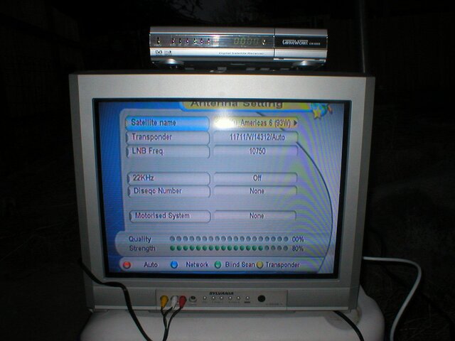
setup screen:
antennascreen.jpg

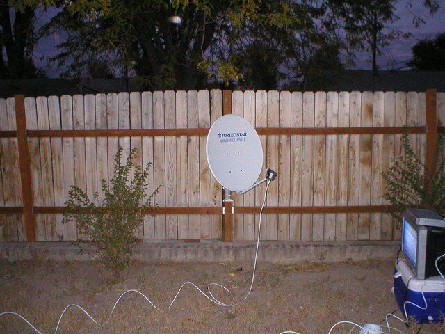
photo taken facing south (lnb is skewed, didn't help)
facingsouth.jpg

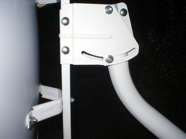
elevation is set in the neighborhood of 37 (got the signal to peak at 80 at this elevation).
elevation.jpg


Well, it's getting dark and starting to cloud over. time to haul my junk into the house and try again tomorrow.

ARRRGHGHGHGH!!!! :mad::mad::mad:
 
thank you for pictures :)

The settings on the box are right :)

The skew is right :)

looks like it may be the elevation...try and lower it a little bit at a time. Looks like its aimed in the right place but that little bit of elevation can make a HUGE difference
 
thank you for pictures :)
No, thank YOU for looking at them :cool:
looks like it may be the elevation...try and lower it a little bit at a time. Looks like its aimed in the right place but that little bit of elevation can make a HUGE difference

That'll be the first thing I mess around with tommorrow.

How do I know that I'm pointed at the right azimuth? The quality bar never once jumped above 0. As i said, the strength bar varied from 70-80. Here's something interesting (worrisome?), when i choose a different satellite name (the first option), the strength would usually stay 80. On only a few birds as i scrolled through them did it drop down into the mid 70s. Is this helpful information in any way?

I was really looking forward to catching the game tonight, but I guess now I have 2 weeks to get up and running before the next one - though i'd still like to get it tomorrow;)
 
How do I know that I'm pointed at the right azimuth? The quality bar never once jumped above 0. As i said, the strength bar varied from 70-80. Here's something interesting (worrisome?), when i choose a different satellite name (the first option), the strength would usually stay 80. On only a few birds as i scrolled through them did it drop down into the mid 70s. Is this helpful information in any way?
the signal means the LNB has power. I've noticed the signal moves when I'm on a satellite and moves higher when I'm close but the elevation may be off...right now I was aiming my 6 footer for a satellite and the elevation was off. signal showed 85 but 0 quality...dropped the elevation a smidge and 85 signal 70 quality so you are probably close.

Once you hit the right info that is on the satellite the quality bar will move. Digital you need to be right on or the signal wont come in. If you feel you're close scroll through the satellites and transponders and see if you hit anything. Below is a list of the strong transponders on each satellite. 93 is good because its smack dab in the middle of about 8 satellites that have stuff on them. 87,89,91,95,97 all have stuff on them 24/7 so if you're close you may hit one of them.

Here is the list

http://www.satelliteguys.us/760777-post1.html

I was really looking forward to catching the game tonight, but I guess now I have 2 weeks to get up and running before the next one - though i'd still like to get it tomorrow;)
PM me your address and I'll send you a DVD of it ;)
 
. If you feel you're close scroll through the satellites and transponders and see if you hit anything. Below is a list of the strong transponders on each satellite. 93 is good because its smack dab in the middle of about 8 satellites that have stuff on them. 87,89,91,95,97 all have stuff on them 24/7 so if you're close you may hit one of them.

Let's see if I get the idea here: once I can hit a transponder on A satellite, I know that I'm the right elevation and I know which direction to move the dish horizontally?
Oh, and
...dropped the elevation a smidge...
how small should these increments be? are we talking the smallest discrete units we can manage? how long in between smidges should i wait for for the quality bar to move?

PM me your address and I'll send you a DVD of it ;)
Done! Thanks! :D
 
Let's see if I get the idea here: once I can hit a transponder on A satellite, I know that I'm the right elevation and I know which direction to move the dish horizontally?
correct. Now since you are aiming for a satellite that is not near your true south (true south means the satellite at the same longitude as you) the elevation does change a little bit...see attached

87.00° W - AMC 3 34.30°
89.00° W - Galaxy 28 (IA 8)-- 35.10°
91.00° W - Galaxy 11 36.00°
93.00° W - Galaxy 26 (IA 6 / T6) 36.70°
95.00° W - Galaxy 3C 37.50°
97.00° W - Galaxy 25 (IA 5 / T5) 38.10°
99.00° W - Galaxy 16 38.70°
101.00° W - AMC 4 39.20°

The bolded is what elevation the satellites are in your area. As you can see the closer you get to your true south satellite (113W) the elevation moves up 3/4 of a degree. So if the elevation is off, you'll probably hit a satellite near it.

For me its easier as IA6 (G26) is my true south so the satellites from 87 to 101 are all around 38 degrees but you're getting there :)

Oh, and
how small should these increments be? are we talking the smallest discrete units we can manage? how long in between smidges should i wait for for the quality bar to move?
sorry...I'm so use to using smidges to describe things...
I would move the dish to approx 140 degrees and wait. slowly move it east. I'd move it a little bit and wait a couple seconds then continue. Honestly if you make a mark on the pole I'd move it 1/32" to 1/16" at a time..thats how accurate it needs to be. Once you get near the satellite the quality meter will read low then you can fine tune from there. Seriously though, I've seen people lean into a dish and the signal jump :) 140 is approximate. Get it near there and move in small increments. If nohing, then drop the elevation a degree and repeat. The transponder posted (11711 V 14311) is very strong so if you are near it, it should register a signal and then we can fine tune from there
 
Two small hints that might help.

1. When using the compass walk about 30 feet away from the dish, in the direction of the of the satellite. Make sure you don't have any metal around where you are standing and no metal tools with you.

Turn around and sight backwards toward your dish. Hold the compass up to one eye with the compass about 2 feet away from your eye and sighting down the compass and looking back at the satellite pole, walk to the left or right until your eye , the compass and the pole are all in a line. Of course keeping looking at the reading on the compass. When every thing is lined up set something on the ground then go back to the dish and point the dish in that direction as you starting point.

Then go back out to where you were standing and then aim back with the compass this time looking at the LNB. With one eye see if the LNB looks centered on the LNB arm. In other words If the dish is pointed exactly at you ,the The LNB arm will apear directly behind the LNB and the LNB will be centered left to right in the dish.

2 When I move my dish I move it the smallest I can move and then stop, and count to ten before I move again.
 
Last edited:
It may be the picture is not taken exactly vertical - but it looks like you mast is not exactly vertical. If the mast is off vertical - then the dish elevation settings will be incorrect.
Bob
 
thanks for the compass tips. both my wife and i tried it and we eneded up inthe same spot, so the dish should be aimed about 140ish right now (tho that compassis small and hard to read. who knows, we could be 10 deg off either way).

Here's my foolproof aiming plan

I went into "edit satellite", and removed all of the c-band and only left the ku band sats between 103 and 83. I added a couple from your list ( http://www.satelliteguys.us/free-air-fta-discussion/85225-i-need-strong-transponder-aim-my-dish.html ). On my cw-600s, when i add a new satellite reglardless of wether i specify east or west, it always gets added as E. Since this this isn't powering a motor, am i correct in assuming that the number and direction (ie, 91.0* E) won't matter and is for my benefit only? This is extra important to me since I accidentally deleted 93W when I was going through the list (thought I was deleting the Cband at 93), and now it's readded as 93E.

Now when I go into antenna setting, I can choose from 11 transponders that have known good singal (from that list)

Ku_AMC 1 (103 W) 12100 V 20000
Ku_AMC4 (101 W) 12120 V 30000
Ku_Galaxy4R (99W) 11760 H 30000
Ku_Telestar5 (97 W) 12177 V 23000
Ku_Galaxy3C (95 W) 11780 H 20760
the guy I really want: IA6 (93E) 11710 V 14320 (I added this guy back in manually, hence E as described above, and with values from your list instead of the default from the captiveworks)
G11 (91E) 12060 V 26700
Americas 8 (89W) 11780 H 29000
Ku_AMC3 (87 W) 11736 V 6109
AMC2 (85E) 12194 H 3978
AMC9 (83 W) 12140 V 30000

Here's the plan. Start at about the 40deg elevation marker on the dish (I'm looking for 37 and we're assuming the markers on the dish are off) and more to the east. Go through all 11 of my known satellites/transponers then move a bit west, repeat, repeat repeat until i've moved far enough west. Then move the elevation down about 1 degree, and do it again heading east. then drop down and back west , etc etc. Hopefully somewhere in the I hit one, and then I know which direction both horizontally and vertically to go from there.

ie
40 E ---scan---> W
39 E <---scan--- W
38 E ---scan---> W
37 etc
36 etc
...
29 etc
etc

Is this the way to do it?
 
mast not plumb; tiny compass

Please re-read what WescoPC posted above about your mast.
I just read the thread and noticed that situation and was about to make the same remark.

I actually have one of my dish masts off-plumb by 15º..20º , too.
So, it's not impossible to get working, but it'll make the suggestions given by others in the thread a bit harder to follow.


As for the little compass, I use a quarter-sized POC that came with a DBS antenna years ago.
Here's my trick to using a small compass along with a level to make aiming easier:
http://www.satelliteguys.us/884952-post19.html
 
Here's my foolproof aiming plan

I went into "edit satellite", and removed all of the c-band and only left the ku band sats between 103 and 83. I added a couple from your list ( http://www.satelliteguys.us/free-air-fta-discussion/85225-i-need-strong-transponder-aim-my-dish.html ). On my cw-600s, when i add a new satellite reglardless of wether i specify east or west, it always gets added as E. Since this this isn't powering a motor, am i correct in assuming that the number and direction (ie, 91.0* E) won't matter and is for my benefit only? This is extra important to me since I accidentally deleted 93W when I was going through the list (thought I was deleting the Cband at 93), and now it's readded as 93E.
correct. Since there is no motor you could name it "paulm's satellite" :) As long as the transponder info is put in, that is all that needs to work.

Now when I go into antenna setting, I can choose from 11 transponders that have known good singal (from that list)

Ku_AMC 1 (103 W) 12100 V 20000
Ku_AMC4 (101 W) 12120 V 30000
Ku_Galaxy4R (99W) 11760 H 30000
Ku_Telestar5 (97 W) 12177 V 23000
Ku_Galaxy3C (95 W) 11780 H 20760
the guy I really want: IA6 (93E) 11710 V 14320 (I added this guy back in manually, hence E as described above, and with values from your list instead of the default from the captiveworks)
G11 (91E) 12060 V 26700
Americas 8 (89W) 11780 H 29000
Ku_AMC3 (87 W) 11736 V 6109
AMC2 (85E) 12194 H 3978
AMC9 (83 W) 12140 V 30000

Here's the plan. Start at about the 40deg elevation marker on the dish (I'm looking for 37 and we're assuming the markers on the dish are off) and more to the east. Go through all 11 of my known satellites/transponers then move a bit west, repeat, repeat repeat until i've moved far enough west. Then move the elevation down about 1 degree, and do it again heading east. then drop down and back west , etc etc. Hopefully somewhere in the I hit one, and then I know which direction both horizontally and vertically to go from there.

ie
40 E ---scan---> W
39 E <---scan--- W
38 E ---scan---> W
37 etc
36 etc
...
29 etc
etc

Is this the way to do it?
since the CW600 doesn't have a blind scan, what you just did will work pretty well. Make sure the LNB info (10750) is set properly on each satellite.

As for the relabelling of 93, you have to input the satellite as 257 (360-93) for it to acknowledge west. I have a reciever that does that too
 
Thanks for the compass tip, Anole, I'll do that.

The mast is *fairly* plumb, that picture was at an angle. I used a weight tied to an end of twine and eyeballed it when I set things up. However, I'm just going to drop a proper pole into the ground. The fence post isn't that wide and I don't have a place for the support arms so even when the bolts are all snugged up I can wiggle this thing side to side because the post has some give. Might as well do it right -- I have two weeks.

In the meanwhile, I'd like to paint or otherwise camouflage it -- it's rather large and ugly. Any suggestions?
 
Thanks for confirming that. As I just said, I think since I have the time I'll stick a perfectly plumbed ( :p ) pole in an optimal place in my yard instead of my current installation. I am rather temped to try this plan anyway though, just to prove to myself that I can in fact pick up a signal with this thing:rolleyes:


As for the relabelling of 93, you have to input the satellite as 257 (360-93) for it to acknowledge west. I have a reciever that does that too


Yeah, i thought the same thing, but it would reject any attempt to enter a value over 180
 
You can see why we were concerned:

Based on the incorrect assumption your camera was level... *

- the pole is leaning about 10º to the south (?)
- dish is tilted down another 1º, so that'd put dish elevation at about 23º, when the picture was taken.

Since you used a plumb bob (weight on a string), I'm sure you're within a degree or so of plumb.
And that should be fine for a fixed dish.

I do worry that your fence post is wiggling.
Will the wind make the fence and post move?
The dish will certainly catch the wind.
Not that you can't get on a bird and see some TV, short term... :)

Of course, if you should decide to go motorized in the future, then plumb is the law!
And wiggle is not permitted.


* I got out my angle finder (tilt meter) and did the above measurements from your photo.
 
A friend and I stuck a pole in the ground over the weekend. 6 feet of aluminum buried in a 2 foot (1/3 of the pipe) hole filled with concrete. Now that it's had a couple of days to cure, it's time to stick the dish on there and try aiming. I'll be back this evening either whooping it up over getting it to work, or begging for more aiming tips. Thanks again to everyone for the great help on this project!
 
Paulm, I used a similar method. I used the computer to calculate the degrees on a compass that I needed to point. On my computer, I used a pci satellite card, I added the transponders on "the list", 4 on each side of G26. I then pointed to what I thought was the correct compass setting. I was able to find G25. I moved nearly 3/8 of an inch to the east and I hit G26. It took a good sum of time to do it, but dont give up. The people on this board have been very helpful to me in this process. Best of luck and Go Sioux!
 
My apologies if I repeat anything already suggested as I have not read all the post in detail,,,,,,,

I would suggest you start by looking for Galaxy 97. This satellite is loaded with active tp's and is usually fairly easy to find. It's predecessor was usually very easy to find. After finding it, then I would look for Galaxy 93.
Some calculations and your imagination will then come into play. Calculate the difference between the difference for elevation and azimuth for 93 and 97 for your location. Then use your imagination (and meter if you have one). Imagine a rainbow arch running over your southern line of sight. If these sats are near the top of the rainbow arch then you will be more concerned about azimuth adjustments than elevation since they are only 4 degrees apart on the equator. If these sats are near the edge of the arch then your elevation becomes more critical and the azimuth becomes minimal.

Also, I would suggest in the off season you aim your dish to G10. There are quite a few tv stations being uplinked by Equity Broadcasting. And since you are not on cable then you might like some more choices in programming.

Good luck and a WARNING, once you find your signal, you might become addicted like a of us here.....
 
(very minor but somewhat) success! (I'm on the right track, I think).

I worked on following my foolproof aiming plan this evening, and I had a little bit of luck that I wanted to get some feedback on before proceeding. I aimed at the closest to 140 I could figure out with my crappy keychain compas, then i started scanning the sky, moving through elevation, then moving a bit in azmuth, repeat.

After about 20 minutes, I finally got some flashes of red dots in the quality bar! :eek:

This is on 85W, 12194 H 3978 Auto (per icebergs list of strong transponders)

After a few rounds of tweaking the azimuth and elevation, it got as good as it seemed like it was gonna get: it would keep spiking from 0 to 20-50, never steady, and no picture ever came in.

BUT, can I assume that I'm in the general vicinity of 85W and use that knowledge to get to 93?

elevation does change a little bit...
87.00° W - AMC 3 34.30°
89.00° W - Galaxy 28 (IA 8)-- 35.10°
91.00° W - Galaxy 11 36.00°
93.00° W - Galaxy 26 (IA 6 / T6) 36.70°
95.00° W - Galaxy 3C 37.50°
97.00° W - Galaxy 25 (IA 5 / T5) 38.10°
99.00° W - Galaxy 16 38.70°
101.00° W - AMC 4 39.20°

So I'll need to move 8° to the west? (ie, to the right when facing south)
geosatfinder shows 85W elevation 33.3°, so I'll be adjusting up 3° as well?

Iceberg, you had mentioned that the fortec dishes are off in their elevation markings? what direction? I'm i'm really pointed at 85W, my dish is reading quite high, the marker is right at about 40-41°

Well, I would have liked to see some video coming though to prove to myself that my equipment works:rolleyes:, but I think I've made significant progress today!

here's a 3 second movie that shows what the quality bar is doing:
View attachment fta1.mov
 
(very minor but somewhat) success! (I'm on the right track, I think).

I worked on following my foolproof aiming plan this evening, and I had a little bit of luck that I wanted to get some feedback on before proceeding. I aimed at the closest to 140 I could figure out with my crappy keychain compas, then i started scanning the sky, moving through elevation, then moving a bit in azmuth, repeat.

After about 20 minutes, I finally got some flashes of red dots in the quality bar! :eek:

This is on 85W, 12194 H 3978 Auto (per icebergs list of strong transponders)

After a few rounds of tweaking the azimuth and elevation, it got as good as it seemed like it was gonna get: it would keep spiking from 0 to 20-50, never steady, and no picture ever came in.

BUT, can I assume that I'm in the general vicinity of 85W and use that knowledge to get to 93?
that sounds right

So I'll need to move 8° to the west? (ie, to the right when facing south)
geosatfinder shows 85W elevation 33.3°, so I'll be adjusting up 3° as well?
maybe. I'm wondering if you might be on 89W as there is usually a news feed on 12190 H 3978 but you probably are on 85W so yes go 8 degrees west (right) which is if you make a mark on the mast about 1/8"

Iceberg, you had mentioned that the fortec dishes are off in their elevation markings? what direction? I'm i'm really pointed at 85W, my dish is reading quite high, the marker is right at about 40-41°
oof da...that is really off. I've seen usually high so 35 is really 30. But you are on the right path

What I would do is make a mark on the mast so you know this is 85W. Dial up the 87W Transponder and move the dish until that comes in. 2 degrees isn't much. I wouldnt touch elevation just yet..see if you can get it without touching the elevation. then move the dish up a little bit to lock in 87. go to 89, 91, etc

you're getting there.
 
maybe. I'm wondering if you might be on 89W as there is usually a news feed on 12190 H 3978 but you probably are on 85W

How can we check that? Are there other known strong and on transponders on 85 that for sure aren't on 89 or vice versa?
 
Status
Please reply by conversation.

Music on Dish satellite

How's The Weather?

Users Who Are Viewing This Thread (Total: 0, Members: 0, Guests: 0)

Who Read This Thread (Total Members: 1)