Trying To Get G19 with a Motor
- Thread starter jeff111
- Start date
- Latest activity Latest activity:
- Replies 69
- Views 5K
You are using an out of date browser. It may not display this or other websites correctly.
You should upgrade or use an alternative browser.
You should upgrade or use an alternative browser.
- Status
- Please reply by conversation.
Ok.
On the meter, for the 97w satellite: is the LNB type set to Universal and the LO set to 9750/10600? 22KHz set to Automatic?
On the meter, for the 97w satellite: is the LNB type set to Universal and the LO set to 9750/10600? 22KHz set to Automatic?
Please confirm that the meter settings are as above for 97w. Each satellite can have its own LO selection.
What transponder /polarity / Symbol Rate is selected for 97w?
Time helping someone on the forum helps many who might have similar problem, so prefer to keep the assistance in this thread.
What transponder /polarity / Symbol Rate is selected for 97w?
Time helping someone on the forum helps many who might have similar problem, so prefer to keep the assistance in this thread.
Not sure if that is an active transponder. Use 12152, Horizontal, 20000.
Without an active and strong transponder, the meter will not detect the satellite.
Edit: Confirmed 11737 V 8332 is definitely not an active transponder. This is why you were unable to find 97w.
Without an active and strong transponder, the meter will not detect the satellite.
Edit: Confirmed 11737 V 8332 is definitely not an active transponder. This is why you were unable to find 97w.
That is close enough.I got a 12152/19998/H no 12152/20000
Keep trying. Patience, especially trying to get your first satellite, is a necessary requirement. (my first Ku dish took hours. But then it got easier the more I re-aimed it at other satellites.
Are you using the procedure in post #21 ? Did you raise your Dish elevation? Small, almost unnoticeable steps when moving the dish aim across the green line shown at dishpointer.
Are you using the procedure in post #21 ? Did you raise your Dish elevation? Small, almost unnoticeable steps when moving the dish aim across the green line shown at dishpointer.
Is the elevation scale reading accurate elevation when receiving 87w?
If so, aim the dish at the landmark that lines up with DishPointer's 97w Green line, set the elevation to the 97w elevation (or adjust if scale isn't accurate), set the skew to 26. Connect the satellite receiver, select 97w satellite and set LNB type to Universal, LO to 9750/10600, 22KHz to auto. Then do a Blind Scan type scan for all channel types.
What (if any) channel names are logged?
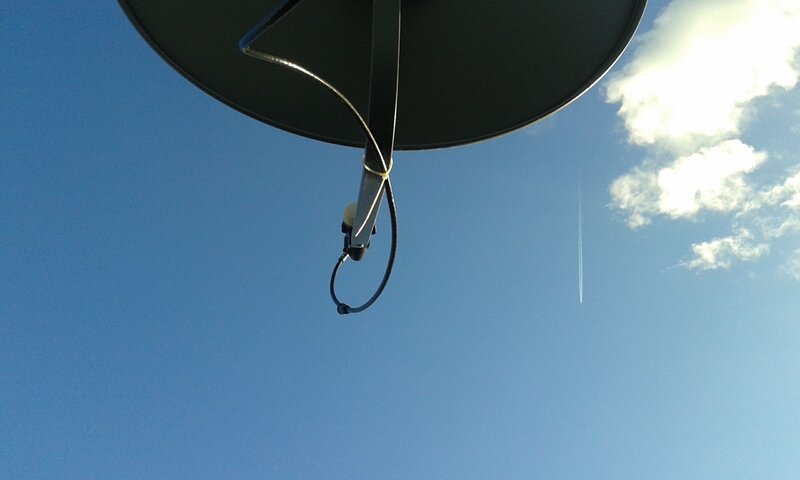
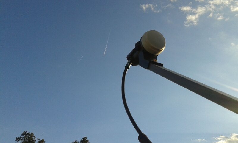
If possible, when the dish is aimed at 97w, stand behind and slightly below the dish and take a few photos of what the dish is aimed at. Wide shot and a shot looking up the underside of the LNBF support arm would be great references for us.
You marked the pole when you got the 87 satellite? Can you find that satellite again? If so, What did/does the elevation scale on the side of the dish mount read? (Trying to see the accuracy of the scale) If it doesn't read just shy of 49 note the inaccuracy. Scale is still correct for the steps it is marked in. just not the total number. Post a picture of the scale?
Post 2, one close up to see the scale and another from 10-15 ft away? (side view)
(pictures are worth a thousand words)
97 (44.7°) is 4 degrees lower than 87 (48.6°).
97W TP 12152 H 20000 (RT)- - - - 87W TP 11737 V 8332 (MTA)
You may be skewed too much**. If the back of the LNBF were a clock face, 1 hour = 30 degrees. To me, in the pic, it appears almost 45 degrees. Think you need around 26 degrees for 97. (?) That would put the coax connector (or the seam on it) from top to bottom on the back of the LNBF) 'close to 5 o'clock but just slightly towards 6:00 for 97W.
Skew at 87 should be about halfway to 5:00 (5:30)
**that's been a reocuring problem I had/have when re aiming dishes, forgetting to set the skew correctly to the 'new' satellite.
Hang in there, we'll get it sooner or later. Rome wasn't built in a day.
Unfortunately patience is required....
There is no reason that the G19 satellite cannot be received as 87w channels are repeatedly received and the sky appears to be open without obstructions. Maybe try another satellite. Get 89w, 91w, 95w and work across the arc? The satellites are there and we just need to figure out if it is an aiming or programming issue.
Did you try the receiver blind scan as suggested yesterday?
Why not remove the difficulties that are present with the current install? Move the dish to a temporary place on the ground (mount the tripod on a pallet) and set up your receiver and a small TV next to it. Forget about the meter and the motor and use just the basic equipment.
I have to assume that the major challenges for your install is being up in the air, learning how to program a meter (not even sure if the meter is working properly) along with sorting out all the new terminology.
Simplify before giving up! I am sure you will be successful if you take a step back and maybe give yourself a break. Reread the advice that we have provided, ask a few more questions and answer a few more of our questions. It can be done and the results are worth it!
- Status
- Please reply by conversation.
Similar threads
- Replies
- 20
- Views
- 681
- Replies
- 17
- Views
- 2K
- Replies
- 27
- Views
- 4K
- Replies
- 21
- Views
- 1K


