Pointing Ku dish using Sun, not compass

Status
Please reply by conversation.
I'll perform a little experiment so you can follow along if you like. First thing you need to do is utilize Google Earth and locate your property. By moving the mouse or cursor over the landscape, you find the precise latitude and longitude (and elevation) of your proposed dish installation. From the image below, I find that my coordinates are 41°33'36.52"N / 96°26'10.66"W.

We need to convert these coordinates to decimal degrees from their degrees/minutes/seconds format so that it can be entered into the solar outage calculator. Divide the minutes by 60 and the seconds by 3600 and add to the degrees. This gives 41.56°N / 96.44°W
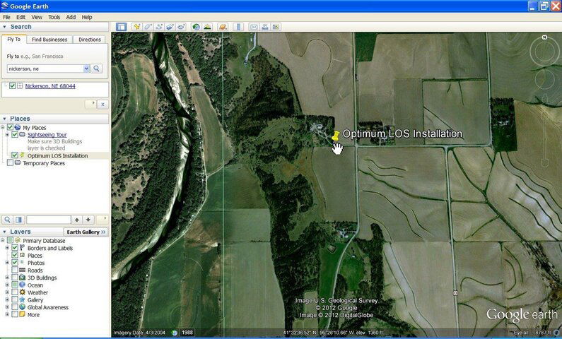
ScreenHunter_02 Jan. 16 03.10.jpg
 
Now I will open the solar outage calculator and start entering my data parameters.

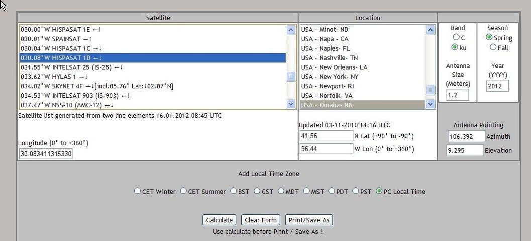
Let's say that I am curious about Hispasat 1D @ 30.08°W. I find that sat in the listing and highlight it.

Next is the location. You can select a city name from the list under LOCATION, but it is better to simply enter your geographic coordinates as we found in the previous post. Enter your coordinates in the boxes below the city names. Notice that you have to enter positive degrees for northern hemisphere latitudes and negative degrees for southern hemisphere latitudes. You also have to enter your longitude as a western hemisphere coordinate, so if you live in Asia or Europe, you'll have to do a conversion.

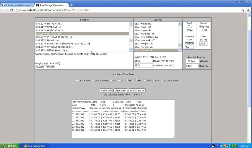
Next select the band (Ku of C), enter the dish size and select the fall or spring outage time period and the year. Then, select local PC time and click on CALCULATE.

ScreenHunter_01 Jan. 16 03.01.jpg
 
From the results, the longest outage period occurs on March 4 between 7:43 and 7:51 am local PC time (that's my time). At 7:47 the sun should be perfectly aligned with Hispasat 1D, so if I look at where the sun is at that time, I know precisely where the sat is as the sat will be perfectly aligned with the center of the sun's orb.

Judging from any interference (trees or buildings, etc) you will be able to spot the best location to install your dish to get the best LOS. The sun will eventually move out of alignment with the satellite, but the satellite of course, will always remain in that same position.

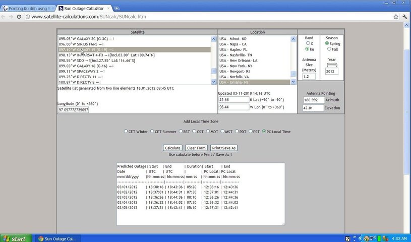
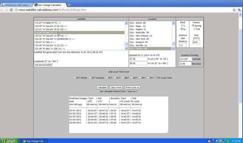
The next step is jut to select all the different satellites that you are interested in and find out what day and time the sun aligns with them. Let's try 97°W from my location...

ScreenHunter_04 Jan. 16 04.02.jpg

Ahh... Around 12:40 pm on March 3rd I should check 97.0°W
 
This is a very simple tool to use. If you wish to use the string and shadow alignment procedure, this calculator will pinpoint the precise time to apply it. I don't use that method as I find it just as easy to set the motor and dish angles according to the manual and then just pan and scan in the general area of the horizon. You honestly end up following that procedure in the end as you peak and tweak your alignments for the optimum signal quality.

The solar alignment calculator is best suited for determining where you are going to locate your dish. It is especially valuable if you wish to set up a motorized dish and cover the broad horizon. It is nice to know what you can expect before you go digging and pouring concrete and running long cables. If you are going to expend work and time and money, you want it as right as possible from the start.

So, at this early time in the year, you should be planning. Select several sites for your dish that seem to be the most logical. Then, when the solar outage occurs, check each of them for the best possible LOS. If you have to select a site further than 250 feet from your house, I would start thinking about RG-11 cable. That's not so much for the signal quality from the satellite, but for the DC current operation of the motor and switches.

RADAR
 
This is a very simple tool to use. If you wish to use the string and shadow alignment procedure, this calculator will pinpoint the precise time to apply it.

The string and shadow alignment could be done, regarding the azimuth only, all year round. In fact, during winter months, when the Sun is low, and the shadow of the LNB is visible on the dish, the string is not needed, providing that the LNB shadow could be located at the axis of symmetry of the dish. The string is needed only for spring - summer - fall seasons. My title of this post is imprecise, promising "pointing dish", but not dealing with elevation. I should have included the words, "azimuth only" and I would ask the moderator to correct it, if possible. Regards, polgyver
 
For those who are really keen there is an open source astronomy program called Stellarium that has a built-in plugin to display satellites, including geo-sync for your location. If you play around with the fast forward feature sometimes you’ll notice a bright star or even a planet that will co-incide with the location of a satellite. Look at what time that occurs at the bottom of the screen then go out at night to see if you can find the star(it helps if you already know the constellations)Something to think about especially if you live in an area without light pollution and the forecast calls for clear skies. It’s still fun to play around and see all the non geo-sync satellites flying around your sky
 
This is a very simple tool to use. If you wish to use the string and shadow alignment procedure, this calculator will pinpoint the precise time to apply it.

The string and shadow alignment could be done, regarding the azimuth only, all year round. In fact, during winter months, when the Sun is low, and the shadow of the LNB is visible on the dish, the string is not needed, providing that the LNB shadow could be located at the axis of symmetry of the dish. The string is needed only for spring - summer - fall seasons. My title of this post is imprecise, promising "pointing dish", but not dealing with elevation. I should have included the words, "azimuth only" and I would ask the moderator to correct it, if possible. Regards, polgyver

Polgyver,

I should have clarified (worded) my statement about the string shadow better. The intent was that it would be a most opportune time to conduct the alignment because you have several benefits working for you. The sun is aligned with the satellite, of course, which makes it a good time to use the shadows. But, you also get the opportunity to judge the LOS interference from trees and such.

I didn't mean to infer that the sun's alignment for the shadow method to line up the azimuth angle of the dish would only be applicable during the two solar alignments (spring and fall). It was merely that it would be a handy time to to work with that while you're also checking for LOS obstructions.

RADAR
 
In early 2000 there was a FTA dish distributor selling a dish with a scale on the reflector and a pointer on a string that ran from the LNBF clamp to the top of the dish. The pointer's shadow would indicate the elevation and azimuth based on the date and time. Anyone remember this distributor from the Memphis Satellite show?
 
Status
Please reply by conversation.

Running a directv moca network on C band coax

EBS Pro satfeeds error

Users Who Are Viewing This Thread (Total: 0, Members: 0, Guests: 0)

Who Read This Thread (Total Members: 1)