No Signal

Status
Please reply by conversation.
sorry but you are incorrect....his dish elevation is 43 degrees....that means the signal is coming in at an angle of 43 + the dish offset angle....normal dish offset would be around 22 degrees....so the signal angle for him would be about 65 degrees....

that is why prime focus dishes always appear to be aimed higher....because there is no offset....

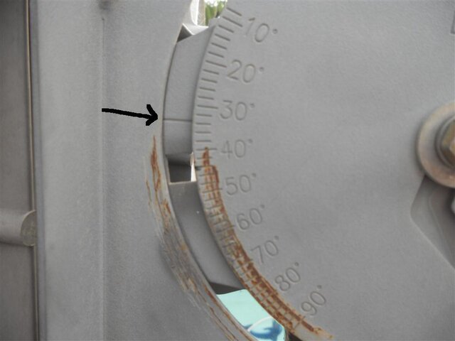
But most dish mounts DO take the offset into account in their elevation scales. I don't know whether his dish does or not, and I don't know what the heck is supposed to be the indicator on his mount either, so I can't say for sure whether he's at the right elevation.

The thing that's bugging me is why his skew should be -60. I have a skew of -40 for Hispasat in Pennsylvania, he's east of me, so he's closer to the satellite's longitude, to it should be closer to south, so it should have LESS skew.

The other thing I'm thinking of is, is his LNB in the focal point? I don't know what the unmodified DirectTV dish looks like or how he's attached the linear LNB, you see.
 
You might try Dishpointer for your azimuth. Satellite Finder / Dish Pointing Calculator with Google Maps | DishPointer.com
As for your elevation set it to 43deg as indicated on the scale on the dish. Never mind this "add 22deg stuff" I don't think that is clear thinking.
Here is what dishpointer looks like for your basic zip code area. Plug in your address for the exact landmark to point at.


6thhev.jpg
 
I have been trying all the great tips here but still not luck. The most dishearting thing is that even going left to right and up and down I still don't get off the 0 on the quality meter. The LNB is brand new but I might get another one tomorrow, same with the box.

Eduardito,

I sincerely doubt that your LNBF is defective as that would be extremely rare. The signal strength reading that you have displayed hints that it is OK. That reading tells you that the local oscillator / internal amplifier of the LNBF is outputting a signal. When you are aligned to a satellite, that signal strength reading should jump up a little bit and then, if the signal from the satellite is strong enough, the signal quality reading should pop in.

My advice to you is to test another satellite. Pick one that you absolutely know that there is no chance for an obstruction to the LOS.

See if any one of these satellites allow you to have a clear LOS and then try to align your dish for the TP listed. Trying another sat will allow you to confirm that you are able to pull in a signal and check your LNBF and tuner. One of these below ought to work for you. Some may not, you will have to check the footprint for Puerto Rico.

Amazonas 2 @ 61.0°W, TP 11810 H SR 27500.
Telstar 14 @ 63.0°W, TP 11960 V SR 4585
AMC 6 @ 72.0°W, TP 12053 V SR 6889
AMC 2 @ 78.9°W, TP 11903 H SR 2170
AMC 16 @ 85.0°W, TP 12040 V SR 27600
AMC 3 @ 87.0°W, TP 11737 V SR 8332
Galaxy 28 @ 89.0°W, TP 11955 V SR 19530
Galaxy 19 @ 97.0°W, TP 12152 H SR 20000
SatMex 6 @ 113.0°W, TP 12080 H SR 25632
SatMex 5 @ 116.8°W, TP 12060 V SR 3077
Galaxy 18 @ 123.0°W, TP 11965 V SR 1999
AMC 21 @ 125.0°W, TP 12180 V SR 30000

RADAR
 
The thing that's bugging me is why his skew should be -60. I have a skew of -40 for Hispasat in Pennsylvania, he's east of me, so he's closer to the satellite's longitude, to it should be closer to south, so it should have LESS skew.

That LNBF polarization of -60.5° is bugging me, too!

That seems quite a large adjustment for this. For me, in Nebraska I calculate -45.9°! Eduardito's cannot be more than mine! I am ~30° west of his location, so he definitely should have less of a polarization angle than I.

Or is it because of our difference in latitude? Evidentally so. I get the same answer from two different calculators.

RADAR
 
Last edited:
Yep! If I use my latitude (41.6°N) and Eduarditos longitude (66.1°W) I get a LNB polarization angle of -33.6°.

So the latitude really affects how we look at the sat's tilt from an earth station. The -60.5° polarization angle is correct..0°.

If you are on the equator, the LNB polarization is going to be -90.0° and theoretically, if you could see the sat from the North Pole, it would be near 0° polarization.

RADAR
 
Last edited:
The LNB polarization is also hard to judge. They didn't make that one very handy to read, did they. If that raised rib on the LNB is truly the zero degree mark, that is a strange animal in my way of thinking. If you set it to zero degree polarization, then the cable would be sticking out the side and not straight down. Wouldn't it? That's odd.

RADAR

The Xtreme II has a weird spot for 0 skew. Its on the side of the LNB so 0 skew the coax is sticking out of the side. I mentioned that to him in a PM about the notch which he marked properly

and yes the closer you get to the equator the skew will be more....that is why I wondered why Miami has a bigger skew than I do in Minneapolis for this sat :)
 
Also I think that line should be where it needs to be lined up with for the elevation

and for the folks who are wondering...those dishes are offset dishes. D* and E* in Puerto Rico need larger dishes due to footprint. Dish has actually launched satellites that have a better coverage in PR so they can use a 30" dish now instead of 4 or 6 foot dishes
attachment.php
 

Attachments

  • dscn0427z.jpg
    dscn0427z.jpg
    46.4 KB · Views: 2,158
The Xtreme II has a weird spot for 0 skew. Its on the side of the LNB so 0 skew the coax is sticking out of the side. I mentioned that to him in a PM about the notch which he marked properly

and yes the closer you get to the equator the skew will be more....that is why I wondered why Miami has a bigger skew than I do in Minneapolis for this sat :)

I was confused with the difference in the latitude vs LNB polarization. I have been using my motorized dish for so long (and I have been without a single, fixed point dish for that long) that my mind was not in gear for that ponderance.

I wonder why they designed the Xtreme II LNB that way? It seems so unnatural.

I think I would set it to ZERO and then make "tick marks" on the housing of the LNBF at every major degree mark and then rotate the LNBF and use the "tick marks" to help get the polarization angle more accurate. You know, sort of transfer the scale to the LNBF so that you can tell where you are at once you rotate it beyond the scale on the clamp. Right now, in the position that Eduardito has the LNBF positioned, there is no scale to read from what-so-ever, so it is anybody's guess as to whether it is at 60.5 degrees or 58° or 62.0° or anywher in between, etc. It leaves too much up to guestimation.

RADAR
 
Also I think that line should be where it needs to be lined up with for the elevation

and for the folks who are wondering...those dishes are offset dishes. D* and E* in Puerto Rico need larger dishes due to footprint. Dish has actually launched satellites that have a better coverage in PR so they can use a 30" dish now instead of 4 or 6 foot dishes
attachment.php

Ice,

So you think it should be near ~33.5°? Not 43.8°? Is this something to do with the specific dish he has, or his latitude position, or both?

Excuse me for questioning this - I don't doubt your judgement as I understand that you have discussed this in PMs with Eduardito prior. I am just unaware of the reason and a little confused about it.

RADAR
 
I wonder why they designed the Xtreme II LNB that way? It seems so unnatural.
RADAR

Radar,

I have one of these lnb's and it works quite well. There is a arrow stamped into the housing on the side and it does indeed represent 0 skew. See post #10 covered by the green marker. He does have it set correctly best I can tell from the picture. The advice to go to a easier to get known sat is good. Find your place and then walk it across the arc.

I did notice that, Pixl. I just found it odd that they would desgn it that way. I mean, WHY? Like I said, it seems so unnatural. Oh well, that is the way they did it.

Beyond that, I definitely do not think that his LNBF is bad and he shouldn't have to buy a new one. It is so uncommon to experience a defective LNBF or even to have one fail. I know it is possible, but so rare. If he bought it at a shop locally, I see no problem if he wants to run down there and ask them to exchange it to satisfy his curioustity, but I truly don't think it is neccessary. That is why I suggested trying another well known sat first. A sat where he is assured to have a good, consistent signal and a good LOS. That should be enough to verify the LNBF and rule it out as being defective.

I would suggest that he try for a sat that is nearest his true south view. Closest sat would be Amazonas 1 or 2 at 61.0°W. I wish it were a better sat than this. I cannot get anything from Amazonas 1 here and Amazonas 2 is just newly on board and I only get one TP. I am not sure if that TP is going to be valid for Puerto Rico. Next nearest to his true south would be AMC 6 @ 72.0°W. For either, he would have to investigate the footprint for Puerto Rico. There is Telstar 14 @ 63.1°W, but that may be questionable.

RADAR
 
Ice,

So you think it should be near ~33.5°? Not 43.8°? Is this something to do with the specific dish he has, or his latitude position, or both?

Excuse me for questioning this - I don't doubt your judgement as I understand that you have discussed this in PMs with Eduardito prior. I am just unaware of the reason and a little confused about it.

RADAR

no what I'm saying is that edge is what should be at 43....the dish seems to be too low on elevation. Unless that is just for show (that line) I know some dishes use the centre of a nut but I've always used the rule that if there is a line (or you can see the edge of the slide scaler) use that.
 
no what I'm saying is that edge is what should be at 43....the dish seems to be too low on elevation. Unless that is just for show (that line) I know some dishes use the centre of a nut but I've always used the rule that if there is a line (or you can see the edge of the slide scaler) use that.

Ice,

Ok, I understand what you meant there now. Initially I thought you meant that the line was properly aligned to the degree scale where you thought it should be - but that is not the case.
You meant to instruct that the line you pointed to should be aligned to the 43.8° mark on the dish's elevation scale, as opposed to using any other reference marker, like the nut or bolt head.

Many people try to use the nut or bolt head for the alignment marker. I think they do this often because the actual marker is painted on and if they are using a used, older dish, that mark is faded so badly or it is totally absent that they just guess that they need to use the nut or bolt. I am with you on this and I am quite certain that no dish uses the nut for a marker. It is either a painted marker, a raised or embossed line or a stamped scribe line on the metal or the outside edge of a portion or the bracket that can be seen through the cutout window.

So, we all pretty much agree that the dish elevation is set too low. The line you drew the arrow to should be aligned with ~43.8° on the dish elevation scale.

RADAR
 
no what I'm saying is that edge is what should be at 43....the dish seems to be too low on elevation. Unless that is just for show (that line) I know some dishes use the centre of a nut but I've always used the rule that if there is a line (or you can see the edge of the slide scaler) use that.

I am pretty convinced it's the line, I've set it both ways just to check. The pic was taken when I was trying the nut but I think it's the line.
 
like I said try a circular tp first...way easier to find

Freezy,

Sorry but that really does not do Eduardito much good here. First of all, his LNBF is not the right type of LNBF for circular polarity signals. Secondly, the nearest circular bird available is way too far away from 30.0°W to do him much good in this case.

We do understand what you are getting at, however. It is a convenient trick to apply and I have used it myself, unfortunately it isn't applicable in this specific case.

RADAR
 
I am pretty convinced it's the line, I've set it both ways just to check. The pic was taken when I was trying the nut but I think it's the line.

You are correct, it is the line. Stick with that and align that line with the 43.8° mark on the dish elevation scale. At least start there.

Now, how accurate that truly is may be another matter. Let's just assume that it is accurate (it really should be).

The only reason it would be off is if the arm that supports your LNBF was incorrectly bent from the factory or if it has been damaged since and the angle is not proper. I would not suspect this normally, and I don't think that you should suspect it either. However, my brother had a 75 cm Winegard dish where this was the case direct from the factory. The LNBF support arm bend, where it passes under the bottom rim of the dish, was not bent to the full angle.

This error would be extremely rare, you should not concern yourself with it. I only mention it so that if worse comes to worse, you have some information in the back of your mind to contemplate. As, it is possible, but incredibly improbable.

RADAR
 
Im giving up for today, taking another crack at it tomorrow. I-ll try to go slowly over everything again.

Eduardito,

Any progress?

I hope you have had the opportunity to observe the path of the sun in the morning hours to get an idea as to whether or not the tree out in front of your dish has any bearing on your problem. I really don't think it is a problem, personally, but it is always good to assure yourself. Remember that, as long as the sun passes over the top of that tree as it is climbing in the sky, the satellite's path will be even higher (at this time of year) and give you a nice clue. In early March, you should be able to pinpoint the satellite position precisely. Right now, you can at least obtain a general idea.

RADAR
 
Well I finally put a different antenna in a different spot and brought in a professional. Turns out the LNB was bad. Makes me wonder if my original location and original antenna were fine and it was just the LNB all along.
 
Status
Please reply by conversation.

right declination and elevation

Users Who Are Viewing This Thread (Total: 0, Members: 0, Guests: 0)

Who Read This Thread (Total Members: 2)