Flat earth non sense

Status
Not open for further replies.
Trigonometry doesn't exist, it is not written... ;)
Trigonometry appears in books (and stone tablets) that the First Council of Nicea didn't see fit (or didn't have access to) to include.

The Babylonians are thought to have been tracking the celestial bodies and related events (eclipses, equinoxes, etc.) using trig according to interpretations of the Plimpton tablets carbon dated to 1800BC. The First Council of Nicea met in 325AD.
 
Water in level ! On a clear day Take a telescope to the beach you can see farther then 12 miles.
No, you can not. If water levels were truly planar, it wouldn't matter how far away from Toronto that NYDutch's pictures were taken, you should still be able to see the lakeshore.
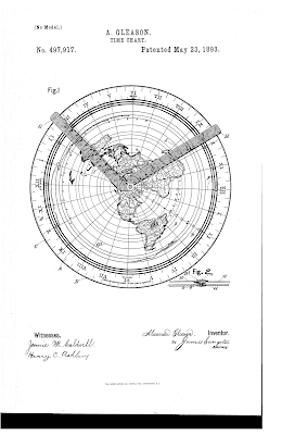
Why would a flat map work the same as a map that is curved? Gleason map
You're not seeing the whole "map". The real "time chart" (Gleason's words), as filed with the USPO shows that there are two hands on the chart that allow you to make calculations (kind of like a slide rule). These can be used to calculate distances.

The time chart doesn't work without the hands. You should note (looking at the zoomable time chart in the patent application itself) that the center point is 90 degrees, about half way out is zero (the equator) and the outside is again 90 degrees. These angular measurements don't make sense on a plane or a half-sphere (dome?).
GleasonDwg.png

Azimuthal equidistant projection - Wikipedia

It may be notable that Alexander Gleason lived in Buffalo, NY, not far from where NYDutch's picture was taken.
Plane's fly only in straight lines.
Planes fly courses and along those courses, the headings change.
North east or North West Still North.
Northeast is 90 degrees different from northwest. That's akin so saying that South is West. Your argument is silly.
Gravity acts on mass??
Absolutely!
Mass is gravity.
No. Mass exists where there is no significant gravity and it never changes (Law of Conservation of Mass).
Why are you not sucked into the ground MASS.
Because the ground is already there and it is generally disinclined to displacement. In the event of quicksand or liquefaction, you may indeed be "sucked in".
 
If you're not learning something from my posts, then yes, you might be a loser.
But you are talking common sense and, OMG, science. Someone here only believes what is written in a certain book. If it ain’t there it doesn’t exist and they will go out on a limb to prove they are right. ;)
 
  • Like
Reactions: TheKrell
Name calling is against site rules. Having a healthy discussion is fine...
 
Has Bob been reincarnated?
;)

Sent from my iPhone using SatelliteGuys


i think he is more like roger/rage with some elements of Mainedish thrown in. In any event all three are entertaining in small doses but the absolute certainty that they (on their own) are smarter than the scientific and engineering communities rubs may the wrong way.
 
Okay, sticking with the satellite aspect of the argument, the satellites I point at for my Dish Network are located in my SW sky. If the satellite is nothing more than a relay device hanging from a balloon, then the elevation and azimuth that subscribers across the United States use to aim at that satellite would be very different for a flat earth than what it is for a spherical earth. (Of course, given the convergence point away from the surface is so far up, a balloon would not be able to reach that altitude, let alone stay motionless.)

So using the elevation & azimuth for South Bend, IN (the city nearest to where I am) you get an elevation of 35.7? and an azimuth of 145.2? from true north for Echostar 15 at 61.5?W. Let's now look at Charlotte, SC, zip code 28101, which is approximately under my line-of-sight to 61.5?W. The elevation and azimuth to the same satellite is 44.1? and 148.4? from true north. So now we have a triangle, one angle 35.7?, one angle 135.9? (180-44.1), which gives an angle of 8.4? at the satellite. Solving for the satellite altitude gives us approximately 2,470 km based on the shortest distance between Charlotte and South Bend of 860 km. That's almost 47 times the record unmanned balloon record of 53 km. So, no, satellites are not hung from a balloon floating above a flat earth.
Did you read my first post here??? No. Read it again the C/ ku signal is bounced off the dome. No balloons necessary? Googles project loon ?
 
C/ ku signal is bounced off the dome.
The only real satellite I have every heard of was hanging from a balloon.
Okay, I misunderstood you to say that Satellite TV is a series of satellites hanging from balloons, my bad.

So you maintain that I point my Dish Network reflector to the Southeast to pick up the signal that Dish transmits from Cheyanne, WY which is West of where I live? If it bounces off the Dome, the source would need to be further to the southeast. Also, given my example for the reflector settings for Charlotte, SC, that would mean that Dish Network would need to have an almost infinite number of transmitter ships in the Atlantic to service the USA.

Anyway, this is a great example of why I rarely wander around the Internet outside of SatelliteGuys.US, but I guess it couldn't last forever… *sigh*
 
  • Like
Reactions: mdonnelly
Okay, I misunderstood you to say that Satellite TV is a series of satellites hanging from balloons, my bad.

So you maintain that I point my Dish Network reflector to the Southeast to pick up the signal that Dish transmits from Cheyanne, WY which is West of where I live? If it bounces off the Dome, the source would need to be further to the southeast. Also, given my example for the reflector settings for Charlotte, SC, that would mean that Dish Network would need to have an almost infinite number of transmitter ships in the Atlantic to service the USA.

Anyway, this is a great example of why I rarely wander around the Internet outside of SatelliteGuys.US, but I guess it couldn't last forever… *sigh*
Use a flash light on a mirror you can shine a wide beam All you meed is 4 locations south of the equator , equal spaced
 
Last edited:
Did you read my first post here??? No. Read it again the C/ ku signal is bounced off the dome. No balloons necessary? Googles project loon ?

How do you explain the satellites and the ISS that can be seen crossing the sky either with the naked eye or a modest telescope? I've seen the ISS pass overhead with enough detail to make out the extended solar panels just using strong binoculars. How do you explain GPS operation without satellites?
 
  • Like
Reactions: Foxbat
Use a flash light on a mirror you can shine a wide beam All you meed is 4 locations south of the equator , equal spaced

Eh? Even if there was a dome, that would have to be one powerful flashlight. How high up is this dome supposed to be above the earth? Where and how does the moon fit into this setup?
 
Use a flash light on a mirror you can shine a wide beam All you meed is 4 locations south of the equator , equal spaced
I can assure you as someone who has aimed a DBS reflector that the signal isn't available just anywhere, it has to be aimed at a very precise location in the sky.

You mention the equator, what significance does the equator have to someone who proposes a flat earth? Is it the half-way point between the center of the flat earth and the edge? Or is it the line on which the Sun appears directly overhead at noon?
 
  • Like
Reactions: NYDutch
Did you read my first post here??? No. Read it again the C/ ku signal is bounced off the dome. No balloons necessary?
If that were the case, wouldn't our signals be coming from uplink stations South of the equator? Something coming out of Colorado or Montana isn't going to bounce back to Seattle or Butte is it? The angle of incidence is equal to the angle of reflection.
Googles project loon ?
Project Loon places balloons at 20km above the surface. This doesn't come anywhere near the triangle that Foxbat calculated. The satellite calculations are based on distances closer to 35,786km (the approximate distance to the Clarke Belt).
 
Last edited:
How do you explain the satellites and the ISS that can be seen crossing the sky either with the naked eye or a modest telescope? I've seen the ISS pass overhead with enough detail to make out the extended solar panels just using strong binoculars. How do you explain GPS operation without satellites?

LEO (low earth orbit) and U2 type high flying aircraft sense the 1950 .
Gps has a map in the memory and your location is from cell towers the more towers the more accurate GPS is.
Bing video Balloons
 
If that were the case, wouldn't our signals be coming from uplink stations South of the equator? Something coming out of Colorado or Montana isn't going to bounce back to Seattle or Butte is it?Project Loon places balloons at 20km above the surface. This doesn't come anywhere near the triangle that Foxbat calculated.
Use a flash light on a mirror you can shine a wide beam.
All you need is 4 locations south of the equator , equal spaced.
Uplink on a different channel to a southern base transmitter to distribute the channels.
 
Or is it the line on which the Sun appears directly overhead at noon?
A bigger question is why does the Sun rise at different times during the day at different locations from East to West and why did we need a time chart such as the one that Alexander Gleason patented. If the Earth were flat, wouldn't the Sun rise at the same time everywhere on the disc/plane?

Related to that, how do we see such long nights in the Northern regions during the Winter? How can the Sun set somewhere without it setting everywhere?
 
LEO (low earth orbit) and U2 type high flying aircraft sense the 1950 .
Gps has a map in the memory and your location is from cell towers the more towers the more accurate GPS is.
GPS works where there are no cell towers and it is much more accurate than cell tower triangulation. GPS with WAAS is good to about 1m in much of the continental US. AGPS comes into play when you can't see enough satellites to get a real GPS reading.
 
Status
Not open for further replies.
Top