Dish Elevation- I'm Confused!

ggw2000

SatelliteGuys Pro
Original poster
Sep 20, 2004
693
110
Out here somewhere
The wife and I just bought a camper in a seasonal campground about 85 miles north of where we live in upstate NY. My plan is to install a dish pointing at 61.5 in order to pickup just the HD off that Sat.
I have a dish at the house here also pointed at 61.5. I decided to build a small apparatus to see if there are any trees in the way and figure out where I can put the dish by the camper.
After building it to the elevation specified of about 38 degrees for that area (mine is at about 39 degrees here) I got looking at it and what appears to be the angle on my home dish. They aren't even close:confused:. I had bought a "angle" finder yesterday and put it on the arm of my home dish tonight and I am getting a reading of about 26 degrees? Looking at it from the side I would say that this looks to be about right. But it is set to 39 degrees by the little markings on the side.
Am I assuming that those markings on the dish have nothing to do with physical reality of level to 39 degrees?
Can someone in the know shed some light on why the big difference?
Sure would appreciate it!
Gerry
 
Was just thinking...

A parobolic dish (BUD) points at the exact elevation of the satellite, while the elliptical dish points at a much lower elevation than the actual el of the satellite.

Was just having a beer;), and it hit me that the LNBF on the dish is offset from center as you say compared to a BUD. This is why the dish physical angle is lower than 38 degrees in my case.
Now comes the question- if i'm looking for clear line of sight in my case, at what angle should I be looking at? I assume that the sat signal is at a real 38 degrees coming into the dish and if I have a good view over the trees at that angle I would be fine?
Gerry
 
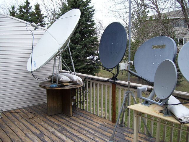
good visual example of a prime focus vs. offset dish

The C-Band dish is at 99 degrees west which for me in Minneapolis is 38 degrees elevation
The dark grey dish is at 97 degrees west so its also at 38 degrees elevation. Look at the way the dish looks. Looks like its almost up and down

Thats why offset dishes clean themselves of snow and the C-Band dish had 6 inches on the bottom of it :)
 

Attachments

  • 000_0444.jpg
    000_0444.jpg
    219.8 KB · Views: 204
I know what he's talking about. I do my own rough sightings as well. :)

Use the 38 degrees (assuming that's the elevation for your area. I'm in western NY and 38 sounds right for the 61.5 satellite. That would be line of sight to the actual satellite. You need that. The angle of the "face" of the dish is not 38 degrees because, as you've discovered, the LNB is offset.

So to determine if you can "see" a satellite (61.5) use that 38 degree figure.
 
cparker (and others)- thanks!

I know what he's talking about. I do my own rough sightings as well. :)

Use the 38 degrees (assuming that's the elevation for your area. I'm in western NY and 38 sounds right for the 61.5 satellite. That would be line of sight to the actual satellite. You need that. The angle of the "face" of the dish is not 38 degrees because, as you've discovered, the LNB is offset.

So to determine if you can "see" a satellite (61.5) use that 38 degree figure.

cparker, you understand my ramblings:). The "dishpointer" website says that the elevation of the dish where the camper is to be 38.2 degrees (union springs area on the north end of cayuga lake). It is 39 degrees down here in the Owego area of NY (makes sense). There is a tree line along the inlet that somewhat crosses the line of sight from the camper to 61.5. I am hoping that I do not have to put the dish up high to clear the trees. I made an apparatus that will mount to my camera tripod (that has a circle bubble on it). I cut an angle on a board of 38 degrees to use as a line of sight to the sat. I figured that I must have clear line of sight at that angle. The physical angle of the dish will be lower of course but won't matter as long as it collects the sat data. Right now I also will look to see if I might be able to put up a 1000.4 dish but it would point to 186 degrees instead of around 171 and would be more perpendicular to the trees therefore probably giving me more problems in clearing the trees.
Thanks to all for there input,
greatly appreciated,
Gerry
 
Iceberg

good visual example of a prime focus vs. offset dish

The C-Band dish is at 99 degrees west which for me in Minneapolis is 38 degrees elevation
The dark grey dish is at 97 degrees west so its also at 38 degrees elevation. Look at the way the dish looks. Looks like its almost up and down

Thats why offset dishes clean themselves of snow and the C-Band dish had 6 inches on the bottom of it :)

Thanks for the visual! As mentioned, hell of a garden you have there! Wife would kill me and bury me under one of them :D.
Gerry
 
Not yet..

The more I think about it, 61.5 should have its own guide data. Have you ran the check switch yet?

I just ordered a 211K yesterday and am trying to figure out whether to put a dish 500 or try and put a 1000.4 up at the lake (if I can clear the trees). I'm just looking ahead at this point (still winter here) and trying to gather info. I'm not sure whether guide data comes off one sat for everything or not?
Gerry
 
But at what angle 38 degrees or the 26 degrees that the dish physically points at?
Thanks, Gerry

The 38 degrees is the actual elevation. With the dish you are offset. It is geometry. Look at the feedhorn to the dish and then the angle made to reflect that line will be 38 degrees. 38 is your look angle and what the dish sees.
 
The easiest rough estimate of satellite location is to sight from the bottom of an offset dish to the top of the lnb.
 

522 Auto tuning problem

Trying to find 119 but 118 takes over!

Users Who Are Viewing This Thread (Total: 0, Members: 0, Guests: 0)

Who Read This Thread (Total Members: 1)